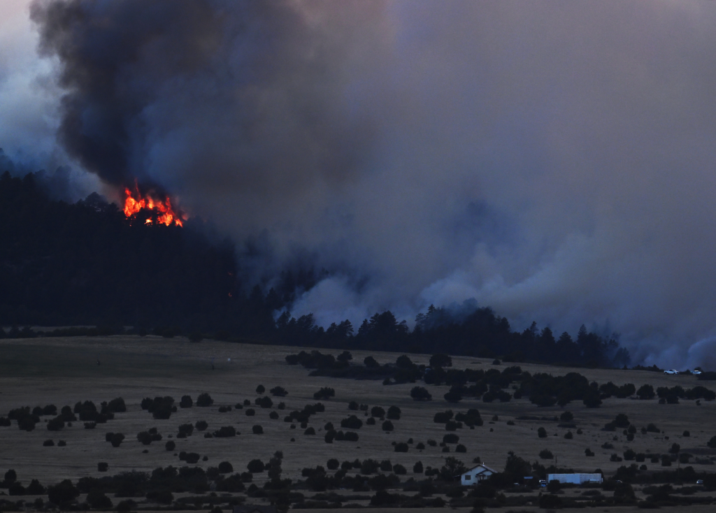
The Aspen Acres fire burning in southern Colorado consumed another 27 square miles overnight and into Friday afternoon, forcing more evacuations and making it the eighth largest wildfire in state history.
Read more Extreme heat bears down as America 250 celebrations ramp up. Trump heads to Mount Rushmore
Firefighters across Colorado expect to face extreme fire conditions today as hot weather, single-digit humidity and wind makes wildfires more dangerous, officials said in Friday morning updates.
The Custer County Sheriff’s Office announced mandatory evacuations for the Wetmore area just before noon and told residents to leave immediately.
“This fire is unpredictable and constantly changing,” sheriff’s officials said.
The Pueblo County Sheriff’s Office ordered new mandatory evacuations for Colorado City shortly before 1 a.m., including west of Interstate 25 between Huerfano County and Burnt Mill Road, west Hatchett Ranch and Burnt Mill Road. Mandatory evacuations remain in Ouray, Lake, Dolores, Pueblo and Custer counties.
Emergency management officials southwest Colorado also ordered more mandatory evacuations for the Ferris fire after activity picked up Friday afternoon, including the area east of Montezuma County Road 16.
Together, the Aspen Acres, Gold Mountain, Snyder, Ferris and Willow fires have charred 157,652 acres — more than 246 square miles — as of Friday afternoon.
This is a developing story and will be updated.
Jump to: Aspen Acres fire | Gold Mountain fire | Ferris fire | Willow fire | Snyder fire | Air quality alerts
Aspen Acres fire in Custer and Pueblo counties
Pueblo County residents near Colorado City and Wetmore were forced to evacuate on Friday as the Aspen Acres fire raced across 27 square miles in less than a day.
Firefighters faced “extreme fire behavior” as the fire ran into Colorado City, up Table Mountain and to Bondurant Road, the Alaska Complex Incident Management Team said in an 8 a.m. update. Flames have consumed 73,366 acres, or 115 square miles, with no containment as of Friday afternoon.
Pueblo County officials have not released information about damage caused by the fire overnight, but the fire officials said Colorado City was impacted and crews are working ahead of the flames to try to protect homes.
“Under what would pass for normal circumstances, we would expect temps to drop, relative humidity to go up and fire behavior to moderate overnight,” incident command team spokesperson Al Nash said. “We really didn’t see that until close to dawn today.”
Fire officials have had reports of visibility as low as a half mile along I-25, Nash said.
Sections of Lake Pueblo are closed to boaters so aircraft can scoop water for firefighting and may change throughout the day as the winds change.
“Interfering with operations will cause the aircraft to stop their suppression efforts. There is not another suitable body of water nearby for these aircraft to work out of,” fire officials said.
More than 10,000 people are now under mandatory evacuation orders in Pueblo and Custer counties because of the fire, including homes near Lake Pueblo State Park to the north, I-25 to the west and the county line to the south, according to the sheriff’s office.
Areas under mandatory evacuation include:
- Wetmore to Fremont County and Pueblo, closing Colorado 96
- Colorado City: West of Interstate 25 between Huerfano County and Burnt Mill Road, west Hatchett Ranch and Burnt Mill Road.
- Red Creek Ranch: North of Colorado 78 and south of Colorado 96, west of Siloam Road and east to the Red Creek Springs area
- The North Creek area from Central Road to the Custer County Line
Aspen Acres subdivision - Property on 12 Mile Road
- South Pine Drive
- Beulah
- Rye
- San Isabel Lake
- Bishop Castle
Evacuated residents can seek shelter at the Pueblo County Recreation Center, 1650 Cooper Place; the Wetmore Community Center, 95 County Road 393; or at Pathfinder Park in Florence, 6655 Colorado 115.
Road closures because of the Aspen Acres fire as of Friday morning, according to the Colorado Department of Transportation:
- Colorado 96 in both directions between Silver Cliff and Siloam Road west of Pueblo
- Southbound Colorado 67 between the Fremont County line and Wetmore
- Colorado 165 in both directions between McKenzie Junction and South Crow Cutoff
- Colorado 78 in both directions between Colorado 165 and Rock Creek Road west of Pueblo
Northbound Colorado 67 and Colorado 96 are open for people evacuating Wetmore but closed to all other traffic, CDOT officials said.
The wildfire was reported as a spot fire near the Aspen Acres campground shortly before 6 a.m. Monday.
Officials with the U.S. Forest Service and the Colorado Department of Public Safety are investigating the cause of the fire, according to the Custer County Sheriff’s Office.
Gold Mountain fire near Ouray
The Gold Mountain fire northeast of Ouray burned another 5 square miles as winds pushed the fire east toward the Cow Creek drainage and west toward Cutler Creek and Baldy Peak above U.S. 550, according to fire officials.
Flames have consumed 21,031 acres, or nearly 33 square miles, since it sparked Saturday, and crews expect fire behavior to range from very active to extreme fire behavior on Friday afternoon amid warm temperatures, low humidity and wind. There is no containment on the fire.
Mandatory evacuation orders remained active west of the fire, according to Ouray County’s evacuation map.
Read more PNC Bank executive addresses bumpy first week in FirstBank transition
The southern evacuation zone included Lake Lenore and was bordered to the west by U.S. 550, to the north by Cutler Creek, to the east by the wildfire burn area and to the south by Bridalveil Creek. The northern evacuation zone is bordered to the west by Ouray County Road 10, to the north by Cow and Deer creeks, to the east by Lou Creek Pass and to the south by Bald Peak and the wildfire.
Pre-evacuation orders were also issued for southwest Gunnison County, along Coal Creek and the Cimarron Ridge, according to the map.
An evacuation shelter was opened at the Ridgway Secondary School, 1200 Green St., according to county officials.
Ferris fire in San Juan National Forest, near Dolores
Firefighters held containment on the Ferris fire, burning on 48 square miles of near Dolores in southwest Colorado, at 10% overnight.
Flames continue backing down into Doe Canyon and other canyons but has not yet reached the Dolores River, fire officials said in an update Friday morning. Crews are focused on protecting homes and power infrastructure and have been able to save Benchmark Lookout.
Fire officials expect two Super Scooper aircraft to arrive Friday to deliver water from McPhee Reservoir to the fire, the incident management team said in an update on Facebook. The planes can scoop up more than 1,600 gallons of water in 12 seconds to drop over hot spots and suppress flames.
The Ferris fire, which started Saturday as three separate fires north of Dolores in southwestern Colorado’s San Juan National Forest, has consumed 30,706 acres as of Friday morning, which is larger than Grand Junction.
Mandatory evacuations are active for residents east and west of the wildfires, according to the Dolores County Office of Emergency Management. The eastern evacuation area was bordered to the north by Disappointment Road, to the south by the Glade Ranch community, to the west by the fire and to the east by Lone Mesa, according to the office. The western zone was bordered to the north by County Road J, to the south by County Road S, to the west by Cahone and to the east by the Bradfield area.
The U.S. Forest Service also closed the Bradfield Bridge Campground, Forest Service Road 504 to the base of McPhee Dam, Forest Service Road 521 and Forest Service Road 504 “out of an abundance of caution,” federal officials said.
Colorado Parks and Wildlife on Tuesday cut off public access to the Lone Dome State Wildlife Area in Dolores and Montezuma counties, according to a news release from the agency. As fire conditions continue to change, further closures may be put into place for public safety and to support firefighting efforts, wildlife officials said.
Willow fire near Leadville
Firefighters kept the Willow fire near Leadville from growing overnight and crews are focused on protecting structures near Turquoise Lake and to the east, officials said Friday morning.
The fire has burned 2,355 acres, or about 4 square miles, of lodgepole pine and conifer with no containment since it sparked Sunday afternoon.
Mandatory evacuations are still in place near Turquoise Lake, with borders of Rock Creek to the south, Hagerman Pass to the west, Galena Mountain to the north and Leadville to the east, according to the Lake County evacuation map. The Leadville area and homes north of the fire along U.S. 24 are on pre-evacuation status.
Portions of the Pike-San Isabel National Forests are also closed because of the fire.
Snyder fire in Mesa County and Utah
More than half of the Snyder fire is now contained and firefighters kept wildfire growth to an acre overnight in Mesa County, fire officials said Friday morning.
The Snyder fire had burned 30,194 acres and is 65%, up from 49% containment on Wednesday, according to the Rocky Mountain Complex Incident Management Team in charge. That’s roughly 47 square miles and nearly the size of Denver International Airport, which operates on 34,000 acres.
Containment doesn’t mean the fire is fully extinguished, but that crews have managed to secure a control line around a section of the fire’s perimeter. If firefighters construct a fire line around the fire’s entire perimeter, the blaze is considered 100% contained. Crews then remain in the area to extinguish hot spots and ensure the containment holds.
The Snyder fire is the result of Utah’s Snyder Mesa and Jones fires merging and moving into western Colorado, consuming the Western Slope’s Knowles and Gore fires. The flames overtook a group of firefighters responding to the Mesa County fires, killing firefighters Emily Barker, Nick Hutcherson and Sydney Watson.
3 wildland firefighters killed in western Colorado identified
A public memorial for the three firefighters is set for 11 a.m. Sunday at the amphitheater in Grand Junction’s Las Colonias Park, 925 Struthers Ave. The service will be livestreamed online.
Air quality alerts
Wildfire smoke will continue making air quality worse across Colorado on Friday, and the Colorado Department of Public Health and Environment issued multiple alerts for the Front Range and Western Slope.
Fine particulates will likely reach levels that are unhealthy for sensitive groups in the Denver metro, Colorado Springs, Grand Junction, Pueblo, Aspen and Telluride on Friday, state officials said.
An air quality health advisory for wildfire smoke is active for Chaffee, Clear Creek, Crowley, Custer, Delta, Dolores, Eagle, El Paso ,Fremont, Garfield, Gilpin, Grand, Gunnison, Lake, Mesa, Montrose, Otero, Ouray, Park, Pitkin, Pueblo, Saguache, San Miguel, Summit and Teller counties.
Read more Today in History: July 3, beloved TV sheriff Andy Griffith dies
Get more Colorado news by signing up for our Mile High Roundup email newsletter.